Trip overview
This trek takes you into one of Nepal’s most isolated corners, upper Humla district, right on the Tibetan border. It’s a restricted area, so you need special permits, and it’s full camping the whole way after the early villages. No teahouses, no crowds, just high valleys, old yak trade routes, and the Phyajang La Pass at 5,496 m. Everything starts in Simikot (2,910 m), Humla’s main hub, where flights often get delayed by weather and life moves on foot or yak.
Why This Trek Feels Different from Everest or the Annapurna region?
Most people know the busy trails around Everest Base Camp or the Annapurna region loop. Humla Changla Valley is the opposite; very few trekkers come here each year. It’s raw, logistically trickier (camping gear, porters, or mules needed), and physically demanding with altitude and long days. But you get solitude, real local life up close, and landscapes that haven’t been commercialized. If you want something that actually feels off-the-grid in the Himalaya, this is it.

Starting Point: Simikot and the Early Villages
You fly into Simikot (weather permitting, delays are common). From there, the trail heads east, passing through traditional settlements like Bargaun, Thehe, and Dojam (one of the bigger ones in the area).
These villages have layered cultures:
- Bargaun and Dojam mix Tibetan Buddhism with older shamanic (Bon) practices.
- Thehe blends Hinduism with similar local traditions.
There’s now a rough jeep track linking Dojam to Shambayok (not much used) and another dirt road from Takchi to Dhiga, but the area stays peaceful, no real traffic, no bustle.

Following Ancient Trade Routes
Centuries ago, this valley was part of a real caravan path between Nepal and Tibet, salt heading north, wool and grain south, all carried by yaks. Local herders still move animals along these same seasonal routes today. You’ll hear yak bells in the distance and see people living much like before. Walking here puts you right into that ongoing history.
Wilderness After Dojam: Camping and Wildlife
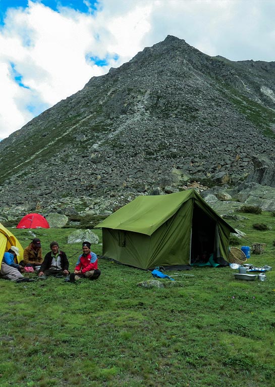
Past Dojam the trek changes, no more villages for long stretches, no lodges at all. It’s pure camping expedition from here: tents, cook crew, open valleys, rocky slopes, high pastures.
This section (especially around Takchi to Chhorten Chhobu) is good for wildlife spotting:
- Blue sheep on steep cliffs
- Wild yaks in meadows
- Herds of kyang (Tibetan wild asses) crossing open ground
The silence hits hard, mostly wind, footsteps, and occasional animal sounds. Nature feels in control.
Crossing Phyajang La Pass (5,496 m): The Trek’s Highest and Toughest Point
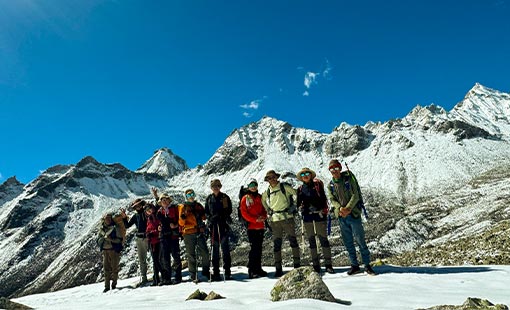
The climb to Phyajang La is long and steady, thin air above 5,000 m makes it tough, but the path is gradual with big views over the Changla Valley. At the top (prayer flags usually flapping), you look back across Humla’s wide spaces and ahead toward Tibet’s plateaus and distant ranges. It’s a solid payoff after the effort, not crowded, just you and the wind.
Descent follows, leading toward the final settlements.
Arrival in Dhiga: Back to Human Presence
After days in empty high country, Dhiga comes as a quiet relief. It’s a small Buddhist village, only a few households, stone houses, smoke from kitchens, small fields under cultivation. Simple daily life feels meaningful after so much open wilderness. It’s a gentle way to ease out of the isolation.
Is the Humla Changla Valley Trek for You?
This isn’t a famous-landmark trek; it’s about remoteness, culture without the tourism gloss, wildlife, and walking old paths in one of Nepal’s quietest Himalayan pockets. Expect strenuous days, altitude challenges, full camping logistics, and permit hassles. The best months are usually May–June and September–October (avoid the monsoon).
If you’re fit, patient with weather/delays, and want a genuine frontier experience far from the standard routes, this one stands out. Few people do it, so stories from here stay rare.
Humla Changla Valley Trek Highlights
Remote and rarely explored trekking route in Upper Humla, close to the Tibetan border
Starts from Simikot, one of Nepal’s most isolated mountain towns
Walk through culturally diverse villages like Bargaun, Thehe, and Dojam, where Buddhism, Hinduism, and shamanistic traditions coexist
Experience the historic Changla Valley trade and caravan route, still used by local yak herders
Full camping trek after Dojam, with no teahouses—true wilderness experience
High chance of spotting wild yaks, blue sheep, and Tibetan wild asses (kyang)
Cross the dramatic Phyajang La Pass (5,496m)—one of the highest trekking passes in western Nepal
Vast views of the Humla highlands and Tibetan mountain ranges from the pass
Visit remote Buddhist settlements like Takchi and Dhiga, untouched by modern tourism
Peaceful alpine landscapes, wide valleys, and complete solitude
Ideal for experienced trekkers seeking an authentic, off-the-grid Himalayan journey
Humla Changla Valley Trek Itinerary
Expand AllWelcome to Kathmandu (1,350m)
Welcome to Kathmandu, the lively capital of Nepal. As your plane lands, you may catch your first views of the Himalayas in the distance. At the airport, our team will meet you and take you to your hotel. Once you’ve settled in, we’ll have a short briefing about the trek ahead. The rest of the day is free to rest or take a gentle walk around the bustling streets nearby.
Kathmandu to Nepalgunj (150m)
Today, you will fly from Kathmandu to Nepalgunj, a town in the lowlands near the Indian border. The flight takes about an hour. If the sky is clear, you can catch views of the Annapurna and Dhaulagiri ranges. For the best view, sit on the right side of the plane. After landing, you’ll head to our hotel. Nepalgunj has a very different feel from Kathmandu—warmer and more open—and it’s a nice first glimpse of the variety Nepal has to offer before the trek begins.
Fly to Simikot (2,910m)
Today you take an early morning flight from Nepalgunj to Simikot, the gateway to the Changla Valley Trek. The flight is short but offers some of the most beautiful views of the Himalayan ranges, with snow-capped peaks stretching across the horizon. As you approach Simikot, the landscape shifts from flat plains to rugged hills and valleys. Once you land, our team will assist with your transfer to the lodge, where you can rest and breathe in the fresh mountain air. After some rest, you will take a day hike to Buraunse Village to experience the local lifestyle, enjoy traditional food, taste local wine, and then hike back to Simikot for an overnight stay at the lodge.
Trek From Simikot to Dojam (2,540m)
Today you begin your trek from Simikot to Dhojam. Along the way, you pass through the Nyin Valley, where the local people are friendly and often greet you with smiles. You will get to enjoy seeing the mountains around you and glimpsing how life comes and goes in this remote part of Humla.
Trek From Dhojam to Shambakong (Mathillo Shangu) (3,186m)
Today you walk from Dhojam to Shambakong (Mathilo Shangu). There’s a newly opened jeep trail along the way, but no vehicles are running yet, so you will follow it on foot. The path goes through junipers and pines. The smell of the forest is strong, and the air feels fresh.
You’ll see flowers along the trail. A few small wooden bridges cross clear streams. It’s simple, but the scenery keeps you moving.
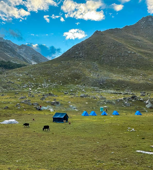
After about five hours, you reach Shambakong. It’s a wide meadow with yaks grazing.
Trek From Shambakong to Fwaji (3,585m)
Today you walk from Shambakong to Fwaji. The trail takes about six hours with some ups and downs along the way. We pass through patches of juniper and birch trees, and trails goes along with Humla karnali.
By afternoon you will arrive at Fwaji. It is a quiet place at 3,800 meters, a good stop for the night.
Trek From Fwaji to Gurukpa (3,985m)
Today you walk from Fwaji to Gurukpa, a steady climb that takes around six to seven hours. The trail passes through pine and rhododendron, with streams crossing the path from time to time via Koron valley. As you go up likely to see Chagla Himal range.
By late afternoon, you will reach Gurukpa, a summer pasture used by herders. The wide, open meadows here make a good campsite. As the sun sets, the mountains around slowly change color, giving a peaceful end to the day.
Trek from Gurukpa to Sumna (4,290m)
You leave Gurukpa and start walking to Sumna. The trail goes up and down a little, and it takes about five to six hours. Along the way, you cross some small streams, and the path is mostly open land with some alpine trees here and there.
You may meet local people with their yaks. On the hills, if you’re lucky, you might see wild yaks or blue sheep. It’s quiet and far from any busy places.
Trek from Sumna to Phyajang base (4,556m)
Today’s trek from Sumna to Phyajang base takes around 5 to 6 hours. The trail moves steadily through the valley, winding past streams. Mountains rise on either side, creating a peaceful and open feeling along the path.
After a few hours, you will arrive at Phyajang base, a calm spot surrounded by mountains. It’s a good place to rest, take in the view, and appreciate the simplicity and serenity of the valley. The landscape leaves a lasting impression and reminds us why trekking in this part of Humla is so special.
Trek from Phyajang Base to Nying Kuna (4,817m) (Yak kharka) via Phyajang La pass (5496m)
After staying overnight at High Camp, the trek today to Nying Kuna feels much easier and more comfortable. You cross Phyajang La Pass (5,496m), the highest point on this part of the trek. The rest from the previous day makes the climb smoother for everyone.
The trail offers stunning views along the way. Snow-capped peaks, wide valleys, and the distant Tibetan ranges create a breathtaking panorama. The path gradually descends, winding through rocky sections and open slopes.
After about 6 to 7 hours, you will reach Nying Kuna, a peaceful spot surrounded by mountains. Here, you rest and enjoy the scenery, feeling accomplished after a challenging but rewarding day.
Trek from Nying Kuna to Chhorten Chhobu (4571m)
Today’s trek to Chhorten Chhobu is gentle trek compared to the previous days. The trail is wide gentle and the elevation gain is low, moving gently across wide valleys and soft slopes. There is ample time to enjoy the surroundings and fresh mountain air.
After you wind your way through the long trekking, you will arrive at Chhorten Chhobu. Chhorten Chhobu is comfortable, quiet, open and new. Opportunity to stop here is welcome and a moment to rest while enjoying the welcome of mountains.
Trek from Chhorten Chhobu to Takchi (4,230m)
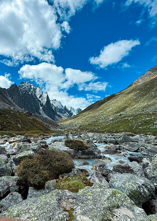
Today’s trek will definitely be one of the most memorable days of our journey, probably one of the prettiest, as you will be walking 5-6hours down the valley towards that of Takchi. It’s certainly a treat every step of the walk as the valley opens up with wide vistas around us. The same streams cross the path again and again with their placid yet clear sparkling water in sunlight, while high mountains rise around us as a dramatic backdrop.
As you walk, the valley is not completely silent as the wind and the birds above sound out occasionally. Wildlife is quite abundant in this area so keep looking up and down. Trekkers have recently seen everything from wild yaks, blue sheep to even wild asses (kyang) hanging around grazing the pastures. Observing any larger of animals in their native home somehow enhances the day and reminds you what somewhat an untouched valley this is.
Takchi, to us, it is an important place – the junction for the Limi villages and also the connector to the trail that heads to the Mt. Kailash viewpoint, the Lapcha Syar. With open skies and wide feeling landscapes, and feeling like we were on an ancient route, Takchi was an appropriate, peaceful and significant location for the end of this first leg of our adventure.
Trek from Takchi to Talung (4,200m)
Today’s trek is a true bonus, a relaxing amble into Talung Valley. It’s almost certainly one of the loveliest parts of the journey. The trail takes us right along beside Talung Lake, and you’ll have views of Mt. Ardhang La just rising up in the distance. That view? It seriously stays with you long after you’ve finished the trek.
The valley is so peaceful. It’s you, the wind, and the sound of the streams. Oh, and then you walk across the Nying Chu Khola. The stream’s not big, but the water is freezing cold. It’s a quick shock to the system, but actually, it’s actually very refreshing and one of those little things you’ll remember.
As soon as you reach our campsite by the river, you can just unwind. The open valley and far-off peaks make it the perfect place to relax. Sunset views in the evening over the valley while we settle into our tents is a wonderful way to end the day. Just another one of the fond memories of the Changla Valley trek.
Trek from Talung to Tsongsa (3,900m)
Today is a big day because after crossing Phyajang Pass you will climb to the second highest pass on the trek, Nyalu La (approx 5,000m)! When you reach the top, the climb will seem worth it as we enjoy a 360 view of what seem like all the snow-capped mountains around us!
After a short break, you will trek down to Tsongsa which gives us beautiful views of Sheliman Lake and Mount Saipal to the south. The walk from Talung to Tsongsa takes about 6 – 7 hours. The trail from Talung to Tsongsa has a new jeep trail for vehicles but only a few really use the trail so it is still peaceful and trekking bliss! Along the way, you see local people a yak herder, busy going about their daily lives.
Tsongsa is not just a campsite, it was an old caravan hub, where traders would gather in year past. You will camp on a very nice flat area on the periphery of a large valley, with mountains and a river around and a large waterfall in close proximity. This is a nice place to rest!
Trek from Tsongsa to Sechi (3,800m)
Today you will set off from Tsongsa to trek towards Sechi. The trail gently climbs uphill for most of the day, with some rocky stretches that keep things interesting, and you will gradually move into highland terrain with alpine plants and medicinal herbs that the locals have sought after for generations. The valley seems calm and quiet, aside from the gurgling sounds from a river nearby, and the occasional splash of color from a rhododendron tree along the trail.
After walking for about 5-6 hours in a and steady pace you will arrive In Sechi. Sechi is a wide-open grassy space between low hills, a great camping spot in a tranquil setting. The camp will be set up on the banks of the Sechi River, with a view of Lagdok Pass ahead. The meadow is large and wide open, the water is fresh and clean, and the surrounding area is sheltered and quiet making Sechi a relaxed stop before we head into the next day of trekking.
Trek from Sechi to Digha (3,600m)
Today you will cross our last pass, Lagdok La, at approximately 4,200m. The climb to Lagdok La is steady and gradual. When you get to the top, the view opens wide, and the surrounding valleys and peaks come into view. It is always nice to see the reward on a long trek! I always feel a bit special seeing the last big climb of the trek before me.
Once at the top, I start to descend. Eventually the descent becomes steady as you approach Dhiga. The lower elevation makes the walk to Dhiga feel easier, and the air slightly warmer. The landscape is also changing – you will now walk beside green fields, and gentler hills which keeps relaxed compared to the harsher terrain you have crossed above and newly left behind.
By mid-afternoon, you will arrive in Dhiga, a small Buddhist village in the valley, which has stone houses and fields surrounding it. It is peaceful, slow-moving and the end of another long day. To finish our last night ultralight camping, there is nothing like snuggling into your sleeping bag under the stars. You will end the day with a mix of relief, comfort, and quiet joy.
Trek from Digha to Simikot (2,910m)
The trail today leads us gently downhill through fields and stone houses. Along the way, you will meet Khas local people, always welcoming with friendly smiles that brighten the path.
You will cross the Hepka Khola, a refreshing stream that adds one last touch of adventure. By afternoon, Simikot comes into sight. Packs come off, legs can finally rest, and there’s a quiet joy in knowing the journey is complete.
Fly from Simikot to Nepalgunj, then to Kathmandu
This morning, you will take the short flight out of Simikot, leaving behind the high valleys and peaks you’ve been walking through. From the window, the mountains rise sharp and endless — it’s a view that stays with you long after the plane touches down.
At Nepalgunj (150m), the warm air feels completely different from the crisp mountain climate. After a brief stop, you continue your journey back to Kathmandu. The busy streets, the sounds, and the pace of the city feel almost like another world compared to the quiet trails of Humla.
It’s the end of the trek, but the memories of the landscapes, the villages, and the people stay fresh — something to carry long after the bags are unpacked.
Reserve Day (in case of bad weather)
An extra day is allocated as a buffer for delays due to weather conditions, especially for flights from Simikot.
Not quite satisfied with this itinerary?
No worries – every traveler has unique preferences, and we’d be happy to adjust the plan to match your style, comfort, and interests. Let us know what you’d like to add or change, and we’ll create a journey that feels truly yours.
Customize TripCost Includes
- All airport pick up and drop services.
- Accommodations in Kathmandu twin share with breakfast
- Twin sharing basis hotel in Nepalgunj
- Guide, cook and kitchen support staff.
- Mules or porters for luggage on the trekking.
- All meals during the treks, Simikot to Simikot.
- All camping and cooking equipments.
- All camping Charges.
- Clients Airfare Kathmandu / Nepalgunj / and return to Kathmandu.
- Humla restricted area permit fee.
- All travel expenses for Nepali staffs.
- DDC tax.
- All local official donations if any.
- Sightseeing in Kathmandu (Boudhanath, Pashupatinath and Bhaktapur) with tour guide/Vehicle
- First Aid kit
Cost Excludes
- Insurance for Clients and Emergency Rescue and medicines and medicals.
- Sightseeing entrance fees in Kathmandu.
- Personal beverages.
- Lunch and dinner in Kathmandu.
- Domestic access baggage charge (Kathmandu to Nepalgunj weight limit is 20 kg and Nepalgunj to Simikot weight limit is 15 kg).
- Sleeping bag & mattress during trip.
- International flights.
- Flight cancelations & its further more expenses
- Tips
Additional Informations
Accommodation
The Chang Valley Trek – Via Tamgim offers a mix of accommodations ranging from guesthouses, local homestays, and camping. Here’s what you can expect:
- Kathmandu & Nepalgunj: Comfortable tourist-standard hotels with private rooms, Wi-Fi, and modern amenities.
- Simikot to Tamgim: Basic guesthouses and local homestays with shared facilities. The local accommodations provide a warm, authentic experience and homemade meals.
- Remote Areas (Tamgim, Nyalathang, Gurdukpa): Since these areas have limited infrastructure, camping is the best option. Our experienced guides will set up tented accommodations with all necessary camping equipment. You’ll enjoy organic local meals prepared with fresh ingredients, giving you a taste of the region’s culture.
Camping in these remote areas allows you to experience the natural beauty of Nepal, with stunning views and the quiet peace of the Himalayas.
Trip Gallery
Trip FAQs
1.What is the Humla Changla Valley Trek?
It’s a remote, full-camping trek in Upper Humla district, far northwest Nepal, near the Tibetan border. Starting from Simikot, you walk through traditional villages like Bargaun, Thehe, and Dojam, follow old yak caravan paths, cross Phyajang La Pass (5,496 m), and end in small settlements like Dhiga. It’s off-the-grid – no teahouses after the early villages, lots of solitude, wildlife spotting, and real local culture without tourism crowds.
2. How difficult is this trek?
Strenuous to challenging (often graded 4/5 or moderate-hard by operators). Expect long days (5–8 hours walking), high altitude (up to 5,496 m), thin air on the pass, and full camping (setting up tents, no lodges). Previous high-altitude trekking experience is recommended, plus good fitness for steady ascents and variable terrain (rocky slopes, pastures, valleys). Acclimatization is built in, but altitude sickness risk exists.
3. How long is the trek, and what’s a typical itinerary?
Usually 18–24 days total (including Kathmandu/Nepalgunj/Simikot flights and buffers for weather delays). Core trekking is about 12–16 days from Simikot to Dhiga/end point. Sample flow: Fly to Simikot → villages (Bargaun/Thehe/Dojam) → wilderness camping → Phyajang La crossing → descent to Dhiga. Exact days vary by pace and group.
4. What is the best time to do the Humla Changla Valley Trek?
Spring (March–May) and autumn (September–November) are ideal – clear skies, stable weather, dry trails, good visibility on the pass. Summer (June–September) works well too because Humla is in a rain-shadow area (less rain than the rest of Nepal). Avoid full monsoon peaks if possible for mud/landslides, and winter (December–February) for heavy snow and extreme cold at altitude.
5. What permits do I need?
Humla is a restricted area, so you need:
- Humla Restricted Area Permit (typically USD 50 for the first 7 days + USD 10 per extra day; minimum 2 trekkers).
- TIMS card (if applicable).
- Nepal entry visa. All handled by your guide/agency (Firante applies in advance in Kathmandu). Guides are mandatory in restricted zones – no solo trekking allowed.
6. How do I get to the starting point?
Fly Kathmandu → Nepalgunj (about 1 hour), then Nepalgunj → Simikot (short flight, often delayed by weather). Total travel day from Kathmandu is 1–2 days with buffers. Return the same way.
7. Is it full camping, and what about accommodation/food?
Yes – full tented camping after early villages (no teahouses/lodges in the wilderness section). We provide quality tents, sleeping mats, dining tent, kitchen crew. Meals are three times daily (breakfast, packed lunch, dinner) – mostly Nepali/Tibetan-style with veggies, dal bhat, pasta, soups, snacks. Bring personal snacks if needed.
8. Will I see wildlife or special views?
Good chance in the open sections (Takchi to Chhorten Chhobu): blue sheep on cliffs, wild yaks, kyang (Tibetan wild asses), maybe Himalayan birds. Views include vast Humla valleys, Tibetan plateau glimpses from Phyajang La, and distant peaks. No guaranteed sightings, but the area is wild and quiet.
9. Do I need special gear or preparation?
Standard high-altitude camping gear (good sleeping bag -10°C rating, down jacket, sturdy boots, trekking poles, rain gear). We provide tents/mats/duffels. Acclimatize well, stay hydrated, carry basic meds (altitude sickness pills like Diamox if advised by doctor). Prior experience above 4,000 m helps.
10. Is this trek suitable for beginners?
Not really – better for experienced trekkers who’ve done multi-day camping trips and handled 4,000–5,000 m altitudes (e.g., Everest Base Camp or Annapurna Circuit veterans). It’s remote, so self-reliance and patience with weather/delays are key.
11. Why choose Firante for this trek?
We specialize in remote Humla routes, handle all restricted permits/logistics, use experienced local guides from the area, and focus on small groups for authentic experiences. We’ve run this trek multiple times – real knowledge of the trail, villages, and conditions.
You may also like

Everest Base Camp Trek
Everest Base Camp Trek: Experience the ultimate Himalayan adventure with breathtaking views of Mount Everest, Sherpa culture, and iconic monasteries. Perfect for thrill-seekers and nature lovers. Trek safely with proper acclimatization, expert guides, and essential gear.

Lukla to Namche Trek
The Lukla to Namche Trek is where many Everest journeys begin, but it is also a complete journey on its own. You fly into...

Nepal Has Two Faces. Most Trekkers Only See One. Everyone knows Everest Base Camp. Everyone has seen the photos of the Annapurna Circuit. They...

Mane Festival Humla
Mane Festival of the Nyinba community of Humla is one of the most unique festivals in Nepal. This festival reflects the lifestyle and traditions...

Langtang Valley Trek
Overview The Langtang Valley Trek is one of Nepal’s most beautiful and accessible Himalayan journeys. Nestled just north of Kathmandu, the valley combines stunning...
