
Trip overview
Humla trekking begins long before you set foot on the trail. It starts with the flight into Simikot, a small aircraft threading through steep ridges before landing on a short mountain airstrip. When the engine shuts off, the quiet feels immediate and unfamiliar. No traffic, no crowds, no busy trekking hub. Just a trail heading north into one of Nepal’s most isolated regions.
This 20-day journey explores two rarely visited areas of far-west Nepal: the wide, wind-carved Chang La Valley and the remote route to Hilsa on the Tibetan border. The trek crosses Phyajang La Pass (5,496 m), the highest point of the journey, reached gradually over several days of steady ascent.
These trails were not built for tourism. For centuries they were trade routes linking the Tibetan Plateau with lower Nepal. Even today you’ll see traces of that past, old mani walls, stone villages designed for harsh winters, and paths worn smooth by generations of traders and pilgrims.
In the Limi Valley, the village of Halji is home to Rinchenling Gompa, an 11th-century monastery of the Drikung Kagyu tradition. This is not a staged attraction; it’s an active religious place where local people still pray daily. Visitors are welcome, but respectfully so.
Hilsa marks Nepal’s northern frontier, where the Karnali River flows out of Tibet. Traders, pilgrims, and locals cross here with little ceremony, continuing a movement that existed long before modern borders. Standing at Hilsa, you don’t feel like you’ve reached a dramatic endpoint, more like you’ve quietly walked to the edge of a map.
This is a difficult trek. Days are long, the terrain is remote, and facilities are minimal in the high sections. Above 4,000 meters there are no teahouses, roads, or reliable communication. What you gain instead is a rare sense of space and silence; the feeling of being somewhere truly far from everything else.
Humla trekking via Chang La Valley and Hilsa is best suited to travelers who value authenticity over comfort and solitude over popularity.
Why Choose Humla Trekking via Chang La Valley?
Nepal has many famous trekking regions, but Humla offers something increasingly rare: true remoteness.
One of Nepal’s Least-Visited Trekking Areas
Compared with busy routes like the Everest Base Camp or the Annapurna Region, Humla receives very few trekkers. Access is difficult, flights are limited, permits are restricted, and there are no roads beyond Simikot. These challenges help preserve the region’s original character.
Phyajang La Pass; A Real High-Altitude Crossing
At 5,496 meters, Phyajang La Pass is physically demanding but incredibly rewarding. The climb is long rather than technical, and the views stretch across barren ridgelines toward the Tibetan Plateau. On exceptionally clear days, distant glimpses of Mount Kailash are possible.
Living Tibetan Buddhist Culture
Villages in the Limi Valley; Halji, Til, and Jang, maintain a deeply rooted Tibetan Buddhist lifestyle. Monasteries, prayer flags, and mani walls are not tourist decorations but part of everyday life.
Wildlife in an Undisturbed Environment
The high valleys support populations of Himalayan blue sheep and are known habitat for snow leopards, though sightings are rare. Large birds of prey are common, and lower elevations host species such as the Himalayan monal.
Following the Karnali River
Much of the trek follows the upper Karnali, Nepal’s longest river. Here it is raw, fast, and remote, nothing like the calmer stretches downstream. Walking beside it adds a constant sense of movement to the journey.
Best Season for Humla Trekking
Timing in Humla is not flexible.
In Everest or Annapurna, bad weather costs you comfort. In Humla, it costs you days. Sometimes your flight. Sometimes your pass crossing. Everything here is connected, and when one-part shifts, the whole plan adjusts.
There are really only two workable seasons.
April to May
Spring comes slowly in western Nepal. The lower valleys start turning green. Rhododendron shows up in patches. Higher up, the grass returns and the yaks spread out again.
Snow usually stays firm on Phyajang La in April. By May, it begins to soften but crossings are still stable in the mornings. Afternoons can cloud up. That’s normal. You start early anyway.
Temperatures are more forgiving than autumn. Camps feel less harsh at night.
If you prefer slightly warmer air and don’t mind a bit of afternoon weather movement, spring works well.
September to October
Autumn is cleaner.
After the monsoon clears out, the air feels sharper. In October, especially, the visibility can be startling. You see distance properly. Layers of ridgelines that don’t show themselves in other seasons.
But nights are cold. Once the sun drops behind the ridge, temperatures fall quickly. Sleeping gear matters.
Most experienced trekkers choose autumn. Conditions are simply more predictable.
Both seasons work. If you can travel in either, choose the dates that give you more buffer days. That matters more than the month.
Difficulty and Physical Preparation
Let’s be direct. This is a hard trek.
Not technical. Not mountaineering. But physically and mentally demanding in a way that popular routes are not.
Altitude
Phyajang La tops out at 5,496 meters.
At that height, you move more slowly whether you want to or not. Appetite drops. Sleep gets light. Small climbs feel longer than they should.
We build the itinerary to acclimatize properly. Still, altitude does not negotiate. You respect it, or it sends you down.
Anyone joining this trek needs to understand the symptoms of Acute Mountain Sickness and report them immediately. There is no prize for silence.
Daily Walking
Expect 5 to 9 hours most days.
Some trails are clear river paths. Others are rough, stony, and feel older than maps. There are no road exits once you are deep in the route.
If someone needs evacuation, it happens by helicopter if the weather allows. If not, it happens slowly.
That reality changes how you approach preparation.
Fitness
You do not need ropes. You do not need ice tools.
You do need endurance.
Three months of consistent training is a realistic minimum. Long hikes with weight. Stair climbs. Sustained cardio.
If you can comfortably walk seven hard hours at home and feel ready to go again the next morning, you’re on the right track.
If that sounds excessive, this is not the right trek.
The Mental Side
Cold mornings. Basic food. No signal for days. Wind that doesn’t stop.
Some stretches feel longer than they look on the map.
But this is also the reason people remember Humla differently from other treks. It doesn’t entertain you. It doesn’t cushion you. It gives you space and asks you to deal with it.
Trekkers who arrive expecting comfort struggle.
Trekkers who arrive expecting effort usually leave changed.
Humla Trekking: Chang La Valley and Hilsa Border Adventure Highlights
- Cross Phyajang La Pass (5,496m) — Humla’s defining high point, with views toward Mount Kailash on clear days
- Walk the vast, open terrain of Chang La Valley — no crowds, no teahouses, just scale and silence
- Reach Hilsa, Nepal’s northern frontier — a real border crossing with Tibet, shaped by centuries of trade and pilgrimage
- Visit Rinchenling Gompa in Halji — an 11th-century Drikung Kagyu monastery still actively used
- Follow sections of the ancient Karnali salt trade route between Nepal and Tibet
- Trek through Limi Valley villages where Tibetan Buddhist culture continues without interruption
- Spot Himalayan blue sheep, large raptors, and potential snow leopard signs in undisturbed high-altitude habitat
- Experience Humla hospitality — simple, genuine, unhurried — in one of Nepal’s most remote districts
Humla Trekking: Chang La Valley and Hilsa Border Adventure Itinerary
Expand AllArrival in Kathmandu (1,350m / 4,429ft)
Your adventure truly starts the moment your plane descends into the Kathmandu Valley. The city spills out below you, ancient temples tucked between modern buildings, prayer flags fluttering over chaotic traffic, the distant rim of snow peaks reminding you why you came.
Our Firante Treks team will be waiting at Tribhuvan International Airport with a warm smile and a sign bearing your name. We’ll transfer you straight to your comfortable hotel in the heart of Thamel or a quieter neighborhood (your choice). After months of planning, this is your moment to exhale.
Take the afternoon as it comes: wander the colorful lanes of Thamel for last-minute gear, visit the swaying stupas of Swayambhunath (the Monkey Temple) if you’re feeling energetic, or simply sit with a cup of masala tea and watch the world go by. In the evening, we gather for a relaxed welcome dinner and trek briefing. Your guide, someone who knows Humla like an old friend, will go over the route, answer every question, and share stories that make the map come alive. Sleep early; tomorrow we start moving west.
Fly to Nepalgunj (150m / 492ft)
An early wake-up for the short domestic flight to Nepalgunj, the gateway to western Nepal. The hour-long journey is beautiful in its own right—watching the middle hills roll beneath you before the landscape flattens into the hot, green Terai plains near the Indian border.
Nepalgunj is a complete change of scene: warm air, bustling markets, a lively mix of Hindu, Muslim, and Buddhist cultures. You’ll feel the heat after Kathmandu’s cooler valley, but it’s only for a day. Check into your hotel, enjoy a proper shower and air-conditioning, and perhaps stroll the local bazaar, spices, colorful fabrics, and street food sizzling on open grills.
This stop isn’t just logistical; it’s a gentle reminder of Nepal’s incredible diversity. From the lowland heat to the high Himalayas in just two flights—this is the kind of contrast that makes travel here so rich. Dinner at the hotel, an early night, and anticipation building for tomorrow’s leap into the mountains.
Fly to Simikot (2,910m / 9,547ft) & Acclimatization
This is the flight everyone talks about. The small plane climbs sharply over ridge after ridge, the Karnali River carving deep gorges far below, until suddenly Simikot appears as a cluster of stone houses clinging to a hillside, backed by raw, rocky peaks. Stepping off the plane, the air is crisp, clean, and noticeably thinner. Welcome to Humla.
Simikot is the district headquarters and, since mid-2025, is now connected by a rugged, unpaved road to the national network—but it still feels wonderfully remote, with most travelers (like us) arriving by air to save time on the challenging overland route. You’ll check into a simple but comfortable lodge (the last proper bed for a while) and spend the afternoon easing into the altitude. We take a gentle acclimatization walk, perhaps up to a nearby ridge or through the village, visiting a small gompa and chatting with locals who are always curious about visitors.
The views are your first real taste of what’s coming: barren hills dotted with pine, the Humla Karnali glinting far below, and a sky so big it almost feels overwhelming. In the evening, share a hot meal with the crew, organize gear, and let the excitement settle. Tomorrow the boots go on, the tents come out, and the walking begins. For now, breathe deep, you’ve reached the true starting line of one of Nepal’s last great adventures.
Trek Simikot to Dojam (2,540m / 8,333ft) – 6-7 hours
The boots finally hit the trail today, and everything feels different. We leave Simikot behind, descending gently into the green Nyin Valley through pine forests and past small terraced fields. Locals wave from their doorways, women spinning wool, kids chasing goats, and the ancient path winds along clear streams feeding the Humla Karnali below.
It’s mostly downhill with a few gentle ups, easy on the legs after the altitude jump. Wildflowers, birdsong, and the fresh scent of resin fill the air. This lower section still has plenty of trees (pine, walnut, apricot). By afternoon, we reach Dojam, a quiet village blending Hindu and Buddhist homes, with stone walls and fluttering prayer flags.
Camp sets up nearby; wander the village, maybe share butter tea with a family. As stars come out and the river hums in the distance, the real Humla rhythm settles in. Dinner around the fire tastes incredible, and sleep comes deep. Tomorrow we start climbing.
Trek Dojam to Shambayok (Talla Shanu) (3,186m / 10,453ft) – 5-6 hours
The trail climbs steadily today, easing you deeper into Humla’s high country. From Dojam, we follow a well-defined path through fragrant juniper and pine forests, crossing small wooden bridges over crystal-clear streams. The air grows cooler and sharper as altitude builds, and the landscape opens gradually, terraced fields give way to open meadows where yaks graze peacefully.
This section follows an emerging jeep track (still largely unused by vehicles), but the walking remains pure and undisturbed. Fragrant wildflowers border the path in season, and the scent of resin hangs in the breeze. Views expand toward surrounding ridges, with the Humla Karnali visible far below in glimpses.
By early afternoon, we reach Shambayok known locally as Talla Shangu, a serene highland meadow ideal for camping. The site offers wide-open space under a vast sky, perfect for watching the light shift across distant peaks. Our crew sets up tents efficiently, and there’s time to rest, stretch, or simply sit with a cup of tea as the valley quiets.
Dinner is hearty, freshly prepared by the team, and the evening brings that deep mountain stillness. Altitude awareness is key now; hydrate well and sleep early. The legs feel stronger, the rhythm more natural. Tomorrow brings more ascent and even finer views.
Trek Shambayok (Talla Shanu) to Dukling Samba (3,585m / 11,762ft) – 6 hours
Today the ascent continues at a steady, manageable pace, drawing you further into the heart of Humla’s alpine terrain. The trail leaves Shambayok behind and climbs through scattered birch groves and open valleys, often paralleling the Humla Karnali River far below. The forest thins as you gain height, giving way to wider vistas of rugged ridges and distant snow-capped peaks.
This stretch follows sections of a rough, infrequently used jeep track, but foot traffic remains the norm, keeping the experience intimate and unhurried. The air feels noticeably thinner now, so we move deliberately, pausing for breath and photos as needed. Clear streams cross the path regularly, offering fresh water stops, and the landscape carries that classic high-Humla scent of dry earth and juniper.
By mid-afternoon, Dukling Samba appears as a quiet, elevated campsite surrounded by open country. The site is spacious and sheltered, with excellent views down the valley. Tents go up quickly, and there’s time to relax, hydrate, and watch the afternoon light play across the hills.
Evening brings a warm meal from the crew, shared stories around the fire, and the profound quiet of the highlands. Rest well; the body is adapting, and the best of Chang La Valley lies ahead.
Trek Dukling Samba to Gurukpa (3,985m / 13,074ft) – 6-7 hours
The trail gets a bit steeper today, but nothing too brutal, just enough to remind you you’re heading higher. We leave Dukling Samba and wind up through patches of rhododendron and the last real pine trees, hopping over little streams that come rushing down the slopes. Up here, it’s mostly locals and their animals on the path; you hardly see any sign of vehicles, and that’s just how it should feel in Humla.
As we climb, the air hits that perfect crisp level, the kind that makes every breath feel clean and alive. Suddenly, you catch your first proper views of the Chagla Himal—those jagged, snowy ridges poking up, giving you a tease of what’s coming. The ground turns into open, rocky meadows with wildflowers if the season’s right, and there’s this faint herbal smell mixed with the fresh wind.
We roll into Gurukpa in the late afternoon; it’s one of those classic summer yak pastures, wide and rolling, with hills cupping it all around. Yaks amble about, bells clinking now and then, and the camp feels roomy and peaceful. Perfect spot to just sit and watch the sun drop, turning everything golden.
The team gets the tents up quickly, and there’s time to kick back, drink plenty of water, and let the altitude do its thing. Dinner’s always a highlight after a solid day, simple, hot, and hits the spot. Nights are so quiet here; you drift off easily, feeling your body getting used to the height. Good stuff ahead.
Trek Gurukpa to Medokding (4,290m / 14,075ft) – 5-6 hours
A shorter day today, which feels just right after yesterday’s push. We pack up from Gurukpa’s big pastures and head out across rolling high country, mostly gentle ups and downs through alpine scrub and open terrain. The trees are pretty much gone now; it’s all rock, grass, and that big Humla sky stretching forever.
The trail stays straightforward, crossing a few small streams and winding through areas where herders bring their yaks in summer. You might spot blue sheep on the distant slopes if you’re lucky; they blend in so well until they move. The air’s thin but clean, and the walking has this easy flow, giving you time to take it all in without rushing.
Medokding shows up by early afternoon, a quiet, exposed spot with plenty of flat ground for camp. It’s raw and open, with views that make you feel properly high up and far from everything. The crew gets things sorted fast, so there’s space to just sit, sip tea, and watch clouds drift over the ridges.
Evenings here are calm; dinner warms you up, and the stars come out sharp and close. You’re settling into the altitude now, legs a bit tired, but in a good way. Rest up; the valley’s starting to reveal its real character.
Trek Medokding to Changmatang (4,556m / 14,948ft) – 5-6 hours
Another steady day that pulls you right into the core of Chang La Valley. We leave Medokding and follow the trail as it winds deeper into the high basin, mostly gradual climbing through grassy stretches and alongside glacial streams that chatter down from the ridges. The landscape feels bigger here, more open, with rock walls rising on both sides and the air getting that real thin, high-altitude edge.
No trees left at all now; it’s all alpine meadow fading into barren ground, the kind of place where the wind has the final say. You might spot a few blue sheep picking their way across the scree, or yaks grazing in the distance, small signs of life in this vast space. The path is straightforward, but every step builds a quiet excitement: tomorrow’s the pass, and you can feel it coming.
Changmatang appears by afternoon, a wide, flat yak kharka that’s perfect for base camp before the big push. Tents go up with plenty of room, and the views are stunning: peaks all around, sky wide open. Time to rest extra, eat well, and check gear. The crew keeps things light with tea and laughs.
Evenings at this height hit different, cold creeps in quick, but the stars are unreal. You’re tired in the best way, body tuning up for Phyajang La. Sleep tight; big day tomorrow.
Cross Phyajang La Pass (5,496m / 18,038ft) & Descend to Nying Kuna (4,817m / 15,804ft) – 7-9 hours
This is the day you’ve been waiting for, the big pass day. We start early from Changmatang while the air is still cold and fresh. Everyone carries a light daypack, and we move slowly with clear minds.
The trail climbs steadily at first, then gets steeper. We walk through a wide, empty valley with no trees, just loose rocks and stones underfoot, and the wind starts to blow stronger. The world feels small: only the path ahead, your steps, and your breathing.
It is hard work, no question. We go slow, stop often for water, and find a good rhythm. But when you reach the top, everything changes. Phyajang La is a wide, open pass covered in colorful prayer flags. Suddenly, the view explodes with endless rolling hills toward Tibet, far-off snowy peaks, and on a clear day, maybe even a distant sight of sacred Mount Kailash. The wind blows hard, but you feel on top of the world, in a truly wild place.
Going down is also challenging, as the loose stones make your knees work hard, and you have to step carefully. But it gets easier bit by bit, and the ground becomes softer. By afternoon, we reach Nying Kuna, a green grassy area where yaks graze. Plenty of space to rest and breathe deeply again.
Tents go up fast, legs feel heavy, but it’s the good kind of tired. The crew brings hot soup, and we all share stories and smiles about the pass. Altitude is serious today—drink lots, eat well, and rest fully. You’ve done something special. The valley now feels bigger and more open. Sleep will come easy tonight.
Trek to Chhorten Chhobu (4,571m / 14,997ft) – 6-7 hours
A gentler day after the pass, and it feels good to ease back into the rhythm. We leave Nying Kuna and walk through the wide, open Chang La Valley, with mostly flat or softly rolling terrain that lets you breathe easier and take in the surroundings. The path follows remote Humla trails past scattered stone chortens and lines of faded prayer flags fluttering in the constant wind.
This is pure high-altitude wilderness: no villages, no trees, just vast grassy stretches and distant ridges under a huge sky. The solitude is what makes Humla trekking so special. Hours can pass with only the sound of your steps and the occasional call of a bird. In this restricted area of western Nepal, everything still feels untouched, far from the busier routes.
We reach Chhorten Chhobu by afternoon—a peaceful camping spot named after the ancient chortens nearby. Flat ground, sheltered by low hills, with plenty of space to spread out. The crew sets up quickly, and there’s time to wander, sit quietly, or just watch the light change over the valley.
Dinner comes early and warm, perfect for refueling. Nights are cold at this height, but the camping setup keeps things comfortable. You’re deep in the Chang La Valley now, with the Limi Valley section waiting ahead. Rest well—the body thanks you for these quieter days.
Trek Chhorten Chhobu to Takchi (4,230m / 13,878ft) – 5-6 hours
After the quiet high valley, today brings a welcome descent. The trail drops gently through open grasslands and past more chortens, with the wind still your constant companion but the air feeling a touch easier to breathe. Streams sparkle across the path, and the landscape starts to change from less barren rock, with more hints of green in the distance as we edge toward lower ground.
This section stays remote and peaceful, with chances to spot wildlife: blue sheep on the slopes, maybe a wild yak herd far off. The walking feels lighter after the pass, and conversations pick up among the group. Takchi arrives by afternoon at a key trail junction where paths split toward the Limi Valley. It’s a small, sheltered spot with good camping space and views back up the valley we’ve just crossed.
Tents up, hot tea ready, and time to relax. The crew cooks something hearty, and the evening feels celebratory. We’ve made it through Chang La’s heart. Tomorrow we turn toward the border and the Tibetan-influenced villages of Limi. Rest well; the next part of the adventure feels fresh and exciting.
Trek Takchi to Jang (approx. 3,930m / 12,894ft) – 6-7 hours
We leave Takchi and enter the Limi Valley proper. The trail follows the Limi River closely, now with clear water rushing over stones, suspension bridges swaying gently as we cross side streams. The valley narrows a little, with stone houses and barley fields appearing on the hillsides. This is where the deep Tibetan roots of Humla become clear: prayer walls, mani stones, and the quiet rhythm of village life.
Jang is the first real settlement we reach, small, strong, and welcoming. Locals go about their day: herding yaks, drying barley, tending small gardens. We camp nearby, often with a chance to visit the village gompa and hear soft chants drifting on the evening air. It’s a special feeling to be among people whose lives have followed the same patterns for centuries.
Dinner around the fire, stories shared, and the sound of the river lulling everyone to sleep. The altitude is still noticeable, but the cultural warmth makes it easier to settle.
Trek Jang to Halji (approx. 3,670m / 12,041ft) – 4-5 hours
A shorter, easier day along the river, perfect for soaking in the surroundings. The trail stays level or gently downhill, passing barley fields, prayer flags, and more mani walls carved with ancient symbols. Halji feels like a hidden gem: one of Limi’s main villages, home to the ancient Rinchen Ling Monastery (over 1,000 years old).
We arrive early enough to explore: walk the stone paths, peek inside the gompa where monks may be chanting, and watch daily life unfold: women weaving, kids playing, yaks grazing. The village has a timeless quality; you sense how little has changed here despite the outside world.
Camp is set in a good spot nearby, often with views over the fields. Evening brings a relaxed pace—tea, dinner, and quiet reflection. This is one of the trek’s cultural highlights.
Trek Halji to Til (approx. 3,700m / 12,139ft) – 5 hours
We continue down the valley to Til, Limi’s smallest and most peaceful village. The path crosses a suspension bridge over the Tagtsi Khola, then follows green fields and barley terraces. Til sits tucked against the hills, simple stone houses, a small Drukpa Kagyu monastery, and a calm that feels almost sacred.
Time to wander: visit the monastery, watch monks or villagers in their daily routines, maybe share a cup of butter tea with someone who invites you in. The setting is pure and unhurried, exactly why people seek out Humla.
Camp nearby with the river’s gentle sound. Dinner, quiet evening, and deep sleep. The border is close now; you can feel it.
Trek Til to Manepeme (3,970m / 13,025ft) – 6 hours
A bit more climbing today as we head toward the border. The trail ascends to Lamka La Pass (around 4,300m), passing an old meditation cave and offering sweeping views back over Limi Valley. The path is clear but exposed, windy, and open, with dramatic scenery on all sides.
We drop slightly to Manepeme, a quiet high spot that serves as a perfect staging area before the final push to Hilsa. Camp is sheltered and comfortable, with time to rest and prepare. The crew keeps spirits high with good food and laughs.
This is our last night before the frontier excitement builds quietly.
Trek Manepeme to Hilsa (3,640m / 11943ft) – 5 hours
The border day. We follow the Karnali River downstream, crossing a long suspension bridge that sways over turquoise water. The trail hugs the gorge walls, dramatic and beautiful, until Hilsa appears as a small cluster of buildings right at the Nepal-Tibet frontier.
This is a working border: traders with mules, pilgrims heading to Kailash, porters moving goods. Tibet is visible across the river, and the atmosphere is real and understated, no tourist crowds, just daily life shaped by geography. Standing here feels like reaching the edge of something ancient.
We camp nearby, often with views into the restricted zone. Celebrate with a special dinner, and the crew will pour extra effort into it. A powerful, quiet evening.
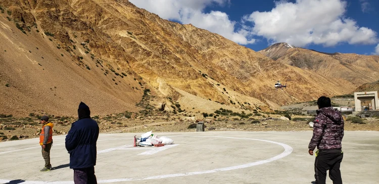
Drive Hilsa to Simikot (2,910 m)
After weeks on foot, we switched to a jeep for the return along the Karnali Valley. The rough, unpaved road winds through gorges and past villages bumpy but scenic, saving energy and time. We reach Simikot by afternoon: hot shower, lodge bed, and a real sense of accomplishment.
Evening meal together, toasting the journey. The remote feeling lingers, but comfort is welcome.
Fly Simikot to Nepalgunj, connect to Kathmandu
Morning flight out of Simikot—views reverse as mountains give way to plains. Connect in Nepalgunj to Kathmandu. Arrive by afternoon or early evening; free time to relax, shop, or reflect on the trek.
Departure / Reserve Day
Transfer to the airport. If the weather delays any flights earlier, this buffer keeps everything smooth. Safe travels home, carry Humla’s quiet strength with you.
Not quite satisfied with this itinerary?
No worries – every traveler has unique preferences, and we’d be happy to adjust the plan to match your style, comfort, and interests. Let us know what you’d like to add or change, and we’ll create a journey that feels truly yours.
Customize TripCost Includes
- Accommodations in Kathmandu twin share with breakfast
- Twin sharing basis hotel in Nepalgunj
- Guide, cook and kitchen support staff.
- Mules or porters for luggage on the trekking.
- All meals during the treks, Simikot to Simikot.
- All camping and cooking equipments.
- All camping Charges.
- Clients Airfare Kathmandu / Nepalgunj / and return to Kathmandu.
- Humla restricted area permit fee.
- All travel expenses for Nepali staffs.
- All pick up and drop services.
- DDC tax.
- All local official donations if any.
- Sightseeing in Kathmandu (Boudhanath, Pashupatinath and Bhaktapur) with tour guide
Cost Excludes
- Insurance for Clients and Emergency Rescue and medicines and medicals.
- Sightseeing entrance fees in Kathmandu.
- Personal beverages.
- Lunch and dinner in Kathmandu.
- Domestic access baggage charge (Kathmandu to Nepalgunj weight limit is 20 kg and Nepalgunj to Simikot weight limit is 15 kg).
- Sleeping bag & mattress during trip.
- International flights.
- Flight cancelations & its further more expenses
- Tips
Additional Informations
Accommodation
The Changla Valley Trek is an extraordinary journey through one of Nepal’s most remote and untouched regions. Given the remoteness of the trail, accommodation varies from comfortable hotels in city areas to full-service camping in the wilderness.
City Accommodation
- Kathmandu: Tourist-standard hotels with modern amenities (private rooms, hot showers, Wi-Fi).
- Nepalgunj: Mid-range hotel stay, often used for overnight transit.
Simikot Stay
- Simikot: Local guesthouse or eco-lodge with basic facilities (shared rooms, local meals, limited hot water and electricity).
Camping (From Simikot onward)
From Dhojam to Dhiga, the route passes through isolated valleys, high passes, and uninhabited alpine zones. As there are no tea houses or lodges, all accommodation is in fully equipped tents arranged and managed by your trekking crew.
Camping Includes:
- Spacious two-person tents
- Dining tent with tables and chairs
- Kitchen tent and experienced cook team
- Toilet tent for hygiene
- Mattresses, pillows, and sleeping bags on request
- Local-style meals prepared fresh daily (dal bhat, Tibetan bread, soups, vegetables, and seasonal greens)
Camping adds an adventurous element and a chance to truly immerse in nature, sleep under starry skies, and wake to views of wild ridges and snowy peaks.
Trip FAQs
1. How difficult is the Humla Chang La Valley trek?
It is rated as difficult. The highest point, Phyajang La Pass at 5,496m, requires sustained effort and proper acclimatisation. Daily walking is 5–9 hours on remote, rough terrain. Previous high-altitude trekking experience is strongly recommended.
2. What is the best time for Humla trekking?
Spring (April–May) and Autumn (September–October) are the optimal seasons. Autumn typically offers clearer skies and sharper mountain views. Spring has more colour at lower elevations and slightly warmer temperatures.
3. Do I need a special permit for trekking in Humla?
Yes. Humla is a restricted area requiring a Restricted Area Permit (RAP) plus standard Nepal trekking permits. Firante arranges all permits as part of the booking; they cannot be obtained independently at the trailhead.
4. Can I see Mount Kailash on this trek?
On clear days from the top of Phyajang La Pass, Mount Kailash is visible in the far distance across the Tibetan Plateau. Visibility depends entirely on weather conditions. The view is not guaranteed, but it is possible, and the pass is worth crossing regardless
5. How do I get to Simikot, the starting point?
Simikot is reached by two flights from Kathmandu, first to Nepalgunj, then onward to Simikot. Both legs are on small aircraft and subject to weather delays. An extra night in Nepalgunj is built into the itinerary as standard practice.
6. What wildlife might I see in the Chang La Valley?
Himalayan blue sheep are commonly seen on rocky slopes above 4,000 metres. The region is known snow leopard habitat, with the best chance of signs or sightings in the early morning at high elevation. Large raptors, Himalayan monal, and wild yaks have all been recorded on the route.
7. Is this trek suitable for solo travellers?
The minimum group size is 2 people. Solo trekking in Humla is not advisable; the terrain is genuinely remote, mobile coverage is minimal, and emergency evacuation requires coordination. All treks are guided by experienced local professionals.
8. What is Rinchenling Gompa in Halji?
Rinchenling Gompa is an 11th-century Buddhist monastery in Halji village in the Limi Valley, belonging to the Drikung Kagyu tradition. It is one of the oldest continuously active monasteries in the region and remains a living religious site.
9. What should I pack for a Humla trek?
Essential items include a sleeping bag rated to at least -20°C, layered warm clothing, a waterproof outer shell, sturdy trekking boots, trekking poles, water purification, high-SPF sun protection, personal first aid, and any prescription medication. A detailed packing list is provided after booking.
10. Can the itinerary be customised?
Yes. Firante can adjust the route to include additional Limi Valley exploration, extend the acclimatisation schedule, or combine the trek with other western Nepal itineraries. Contact the team directly with your requirements.
You may also like

Everest Base Camp Trek
Everest Base Camp Trek: Experience the ultimate Himalayan adventure with breathtaking views of Mount Everest, Sherpa culture, and iconic monasteries. Perfect for thrill-seekers and nature lovers. Trek safely with proper acclimatization, expert guides, and essential gear.

Lukla to Namche Trek
The Lukla to Namche Trek is where many Everest journeys begin, but it is also a complete journey on its own. You fly into...

Nepal Has Two Faces. Most Trekkers Only See One. Everyone knows Everest Base Camp. Everyone has seen the photos of the Annapurna Circuit. They...

Mane Festival Humla
Mane Festival of the Nyinba community of Humla is one of the most unique festivals in Nepal. This festival reflects the lifestyle and traditions...

Langtang Valley Trek
Overview The Langtang Valley Trek is one of Nepal’s most beautiful and accessible Himalayan journeys. Nestled just north of Kathmandu, the valley combines stunning...
