Trip overview
Nepal Has Two Faces. Most Trekkers Only See One.
Everyone knows Everest Base Camp. Everyone has seen the photos of the Annapurna Circuit. They
are great treks, but they come with teahouse menus, lodge beds, and trails worn smooth by
hundreds of thousands of boots.
Far-west Nepal is completely different.
Out here, no teahouses are waiting for you at the end of a hard day. No lodge with a hot
meal already on the stove. You carry your world with you, a tent, sleeping bag, everything, and
at the end of each day, your camp is wherever the mountain allows it. The Api Saipal section of
the Great Himalaya Trail is one of the most demanding and least-travelled routes in the entire
country. Eight high passes. Glaciers. Alpine lakes. Valleys that see only a handful of trekkers each
year.
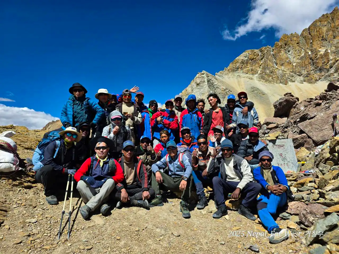
Our Firante Treks team walked this route in 2025. Every single day of it from Simikot to
Dhangadhi. This is the real itinerary from that journey.
What This Trek Actually Is
The Api Saipal GHT section sits in Nepal’s far-western corner, inside the Api Nampa
Conservation Area. The route circles the twin giants of Mt. Api (7,132m) and Mt. Saipal
(7,031m) two of Nepal’s least-visited 7,000m peaks crossing eight major passes along the
way, the highest being Chimalaya Pass at 5,322m.
This is a full camping trek throughout. There are villages on the route, and they are welcoming,
but they are not set up for trekkers. What you will find is something most trekkers spend years
chasing: genuine remoteness, and the quiet confidence that comes from earning it.
Best Season For Trekking
Spring (mid-April to early June) is a popular window. The days are long, wildflowers bloom
along the trail, and the high passes are generally clear of heavy snow.
Autumn (late September to October) brings the clearest skies of the year. After the monsoon,
the air is sharp, and the mountain views of Api and Saipal in particular are at their most
dramatic. Our 2025 team trekked in this season, and the conditions were outstanding.
Avoid the monsoon (July to August). Trails in far-west Nepal during the monsoon can become
genuinely dangerous, especially on high passes. This is not the region to push it.
24-Day Great Himalaya Trail, Api Saipal Section Trek | FarWest Nepal Itinerary
Expand AllArrive Kathmandu | Altitude: 1,350m
Your adventure kicks off the moment you land in Kathmandu. A Firante Treks representative will be waiting at the airport to warmly welcome you and transfer you smoothly to your hotel.
Take this first day easy, rest up, shake off the jet lag, and get everything ready for the trek ahead. In the evening, join us for a relaxed pre-trek briefing where we’ll walk through the route, review your gear, sort out permits, and answer all your questions. It’s the perfect chance to meet your guide and connect with your fellow trekkers over a cup of tea.
Fly Kathmandu to Nepalgunj | Altitude: 150 m
An early-morning flight takes you from Kathmandu to Nepalganj, a busy lowland city in the western Terai near the Indian border. The contrast from Kathmandu is immediate: hotter, flatter, louder.
Nepalganj is essentially a transit point for the far west. You’ll check into your hotel, sort any final gear, and rest up for an early start the next morning. Flights to Simikot are weather-dependent and typically leave early, so an early night is a good idea.
Flight:55 min
Fly Nepalganj to Simikot (2,910m) — Acclimatization Day
An early morning flight from Nepalganj carries you up into the mountains and lands in Simikot — the headquarters of Humla district and your gateway into Nepal’s far west. The flight itself is an experience, with the Himalayan ranges appearing through the window as you approach.
Simikot sits at 2,910m — high enough that your body needs time to adjust before the trek begins in earnest. Today is an acclimatization day. Rest, explore the town at a slow pace, and let the altitude do its work quietly.
Simikot is a fascinating place to spend a day — a remote mountain town that feels completely apart from the rest of Nepal. Traditional stone houses, local markets, and the wide open views of the Humla valley all around you. Talk to your guide, check your gear, eat well, and sleep early. Tomorrow the jeep leaves for Yari.
Flight: 45 min
Drive Simikot to Yari (3,730m) | 6–7 hours by jeep
Your GHT journey begins the moment you climb into the jeep at Simikot. The road drops into the Karnali River gorge, passing the small stone settlement of Lagna before entering Thakuri village territory through Dharapori, Chauganphaya, Danadaphaya, and Majgaun. You will cross Hepka Khola and catch your first real highlight — the thundering Chaynchara Waterfall pouring into the gorge below.
From here the route follows the Karnali through Kermi, Tuling, Yalbang, and Muchu — traditional villages where locals tend their fields and greet passing jeeps with easy warmth. By the time you reach Yari at 3,730m, the valley has opened into a wide mountain plateau and the trek is ready to begin.
Trek from Yari to Jyakthong (3,822m) | 5-6 hours
Your first day on foot begins from Yari — a wide open plateau where buckwheat fields glow red and brown in season, and ancient stone walls line the edges of the valley. With a massive glacier peak sitting directly ahead on the horizon, it is the kind of view that makes you stop before you have even started walking.
The trail climbs steadily through open terrain. You will pass local porters carrying enormous doko baskets — the people who make this trek possible, moving loads through this landscape day after day with quiet strength.
After around 5 hours you arrive at Jyakthong at 3,822m. Camp here under open sky. The temperature drops once the sun sets, so layer up and rest well — the days ahead get harder.
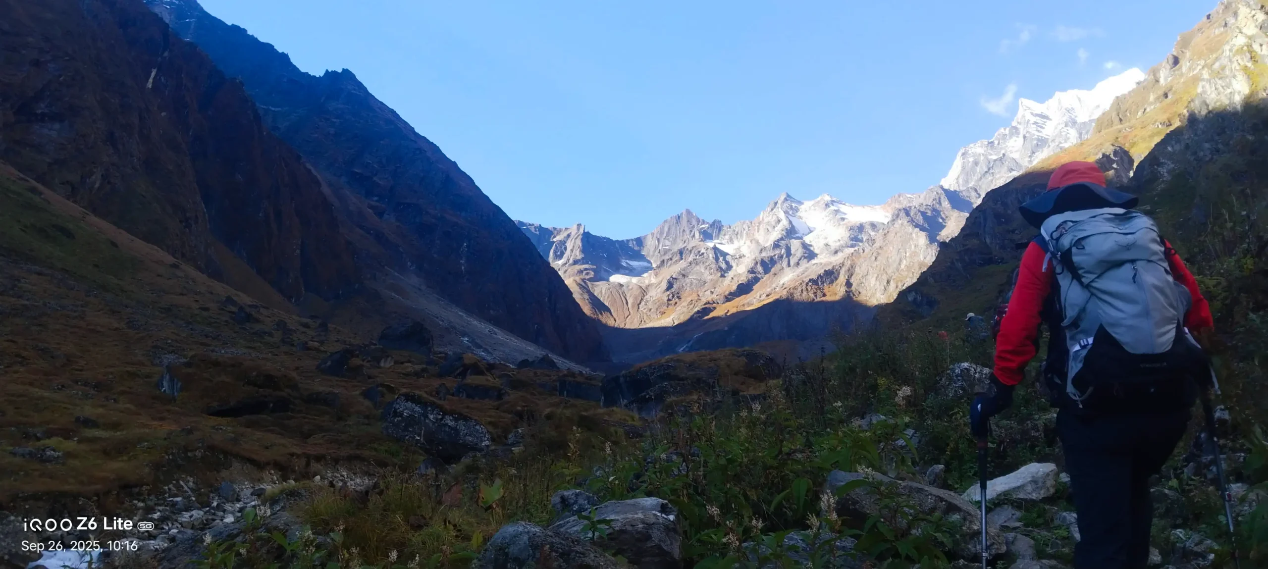
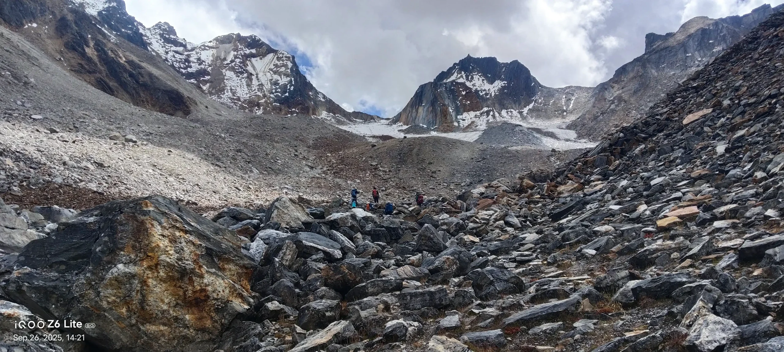
Trek from Jyakthong to Glacier Camp (4,810m) | 6-7 hours
Today, the landscape changes completely. The trail pushes deeper into the mountains, and by midday, you are walking along a milky blue glacial river, ice-cold, powerful, cutting through towering rock walls that rise straight up on both sides.
As you climb higher, the terrain opens into raw glacial moraine — loose rock, grey and brown, with the glacier itself visible above. By the time you arrive, the mountains are right there, enormous, snowy, filling the entire sky.
Glacier Camp at 4,810m is the highest you have slept so far. It is cold, exposed, and completely magnificent. Get into your sleeping bag early. Tomorrow is the hardest day of the entire trek.
Glacier Camp to Thado Dunga (4,573m) via Chimalaya Pass (5,322m) & Thado Dunga Pass (5,218m) | 7-8 hours
This is the day everything comes together and the day that tests you the most.
You begin the long push to Chimalaya Pass at 5,322m, the highest point of the entire trek. The ground is rocky, dry, and demanding. Every step above 5,000m costs more than it looks. But when you reach the pass and stand there with prayer flags snapping in the wind and snow peaks surrounding you in every direction, that feeling cannot be described to someone who has not stood there.
But the day is not over. From Chimalaya, you continue to Thado Dunga Pass at 5,218m, a second crossing above 5,000m on the same day. The descent to Thado Dunga camp at 4,573m is steep and demands full concentration.
By the time you reach camp, you will be tired in a way that feels honest and earned. Eat well. You deserve it.
Thado Dunga to Kalanga (4,245m) | 3-4 hours
A short day, and the body is grateful for it. Three hours of gentle walking through high alpine terrain gives your legs and lungs the chance to recover from yesterday’s double pass crossing. These shorter days are doing real work, letting your body adapt before the next challenge.
Arrive at Kalanga at 4,245m and take the afternoon slowly.
Kalanga to Dhaulachaur (3,624m) | 7-8 hours
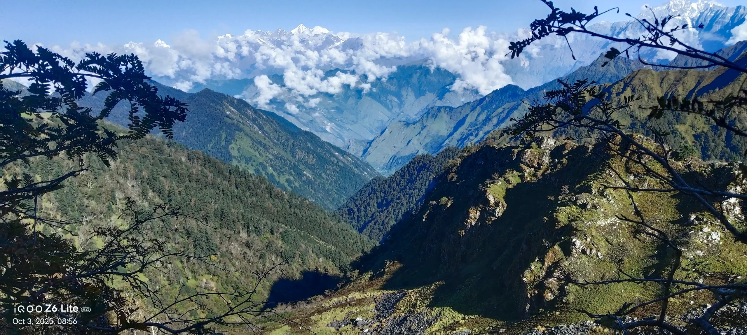
One of the most rewarding days on the entire route. The trail moves through wide open ridgelines with long views in every direction — and on a clear morning, Mt. Api (7,132m) and Mt. Saipal (7,031m) appear on the horizon, standing together above everything else.
Sunlight comes through in long rays, the smoke from a distant camp the only sign of human life in an otherwise completely wild landscape. Let the mountains do their work. Camp at Dhaulachaur at 3,624m.
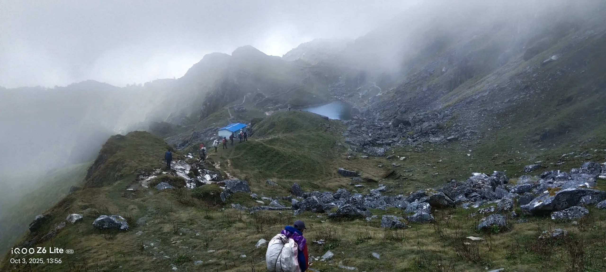
Dhaulachaur to Nilgatti Taal (3,722m) | 3-4 hours
A gentle 4-hour walk that leads to one of the most beautiful spots on the entire trek. Nilgatti Taal is a high alpine lake sitting quietly in a bowl of green grass and rocky ridges at 3,722m. The water is deep blue — perfectly still on calm days, reflecting the hills and sky above it.
A sacred stone sits at the water’s edge decorated with offerings and cloth flags — a reminder that these mountains carry meaning far beyond trekking. Camp right beside the lake. On a clear evening this is the kind of place that stays with you long after you are home.
Nilgatti Taal to Dhanshera (3,760m) via Nilgatti Pass (4,920m) | 7-8 hours
Leaving the lake behind, the trail climbs to Nilgatti Pass at 4,920m. The ascent takes you up through rocky terrain with views opening wide as you gain height — ridge after ridge of Himalayan country spreading out in every direction.
Even on a hard day this route gives you moments you do not expect — a rainbow arching over the mountain behind your tent. The descent to Dhanshera at 3,760m is long but steady.
Dhanshera to Dubai Base (4,015m) via Dhanshera Pass (4,314m) | 6-7 hours
Dhanshera Pass at 4,314m, then a long descent into the broad valley below. By this point the rhythm of climb, cross, descend feels almost natural — which is its own kind of achievement. Camp at Dubai Base at 4,015m.
Dubai Base to Thadeu (3,900m) via Dubai Bhanjyang Pass (4,567m) | 5–6 hours
Dubai Bhanjyang at 4,567m brings open ridge walking with long views and clear sky when the weather holds. A moderate day by this trek’s standards. Camp at Thadeu at 3,900m.
Thadeu to Chhetti (2,890m) via Pathar Rashi Bhanjyang (4,669m) | 7–8 hours
The last major high pass of the trek. Pathar Rashi Bhanjyang at 4,669m demands a serious climb — but crossing it means the hardest part is now behind you.
The descent to Chhetti at 2,890m is a big drop in elevation. The air gets warmer, the terrain gets greener, and something shifts. You can see the valley below opening up, sunlight pouring through the trees, the first campfire smoke of lower country rising in the distance.
Chhetti to Khandeshwari (2,280m) | 6-7 hours
The route enters village country — one of the most culturally rich days of the entire trek. Walking through Gajir, Tothi, Kasaut, Patha, Thumti, and Sabbad, each small community going about its life completely outside the world of trekking tourism. Local ward offices with Nepal flags flying, children watching from doorways, women carrying loads on their backs. Real far-western communities and their warmth is genuine.
Khandeshwari to Khiratoli Pass (3,274m) | 6-7 hours
After the village trail of yesterday, the route climbs again. Khiratoli Pass at 3,274m brings you back into open high country. The contrast between yesterday’s village life and today’s open ridgeline makes both feel sharper and more meaningful.
Khiratoli Pass to Fulltiban (3,840m) | 7-8 hours
A sustained climb through forest and open ground to Fulltiban at 3,840m. By Day 17 the team has found its rhythm completely — the walking feels natural, the silences are comfortable, and the shared effort of weeks in the mountains has built something between people that is hard to explain but easy to feel.
Fulltiban to Chaimatela (3,780m) via Chimatela Pass | 6 hours
Cross Chimatela Pass and descend to camp at Chaimatela at 3,780m. Pass views, valley descent, another honest day completed deep in the far-west.
Chaimatela to Phapu (3,723m) | 6-7 hours
Steady walking along the high route toward the trek’s final section. Camp at Phapu at 3,723m.
Phapu to Lower Thaisain (3,140m) | 7-8 hours
The landscape begins its slow transition — greener, lower, the high alpine world gradually releasing its hold. Lower Thaisain at 3,140m feels like a threshold between the mountains and the valley world below.
Lower Thaisain to Sunshera (1,815m) | 5-6 hours
Through Sina village on the way — warm, unhurried, genuinely welcoming. Reaching Sunshera at 1,815m, the altitude drops away and breathing suddenly feels easy in a way it has not for weeks.
Drive to Darchula / Gokuleshwor (638m) | 6-7 hours by road
The trek is over. The road begins. Darchula at 638m sits on the banks of the Mahakali River — warm, busy, and completely different from everything you have been living for the past three weeks. Seven hours of road and a full change of world.
Drive to Dadeldhura (1,848m) | 6 hours by road
Winding through the hills of far-western Nepal toward Dadeldhura. Terraced fields, small towns, the everyday life of a part of Nepal that most people never see even from a road.
Drive to Dhangadhi (109m), Fly to Kathmandu
The transition back to the capital is always a complicated feeling. The noise, the traffic, the restaurants — everything feels slightly new after what you have just been through. You have walked somewhere most people will never go, and that stays with you quietly — not as something to say out loud, but as a small permanent shift in how big you know the world to be.
Flight: 1 hour
Not quite satisfied with this itinerary?
No worries – every traveler has unique preferences, and we’d be happy to adjust the plan to match your style, comfort, and interests. Let us know what you’d like to add or change, and we’ll create a journey that feels truly yours.
Customize TripCost Includes
All ground transportation as per itinerary (jeep Simikot–Yari, road return to Kathmandu)
Experienced local guide and porter support (1 porter per 2 trekkers)
All meals during the trek — breakfast, lunch, and dinner, full camping style
Complete camping setup — tents, kitchen equipment, dining tent
Api Nampa Conservation Area entry permit and TIMS card
All staff wages, insurance, and equipment
Pre-trek briefing in Kathmandu
Firante Treks digital completion certificate
Cost Excludes
International airfare to/from Kathmandu
Nepal visa fees
Personal trekking gear — sleeping bag (−15°C rated minimum), down jacket, trekking poles
(rental available in Kathmandu)
Travel insurance — mandatory, must explicitly cover helicopter evacuation above
5,000m
Personal expenses: drinks, tips, laundry, souvenirs
Emergency evacuation costs
Trip Gallery
You may also like

Everest Base Camp Trek
Everest Base Camp Trek: Experience the ultimate Himalayan adventure with breathtaking views of Mount Everest, Sherpa culture, and iconic monasteries. Perfect for thrill-seekers and nature lovers. Trek safely with proper acclimatization, expert guides, and essential gear.

Lukla to Namche Trek
The Lukla to Namche Trek is where many Everest journeys begin, but it is also a complete journey on its own. You fly into...

Mane Festival Humla
Mane Festival of the Nyinba community of Humla is one of the most unique festivals in Nepal. This festival reflects the lifestyle and traditions...

Langtang Valley Trek
Overview The Langtang Valley Trek is one of Nepal’s most beautiful and accessible Himalayan journeys. Nestled just north of Kathmandu, the valley combines stunning...

If you’re craving a true off-the-beaten-path Himalayan adventure, the Saipal Base Camp Cultural Trek delivers in every way. This 17-day journey takes you deep...
